The Friends of Maxwell Hall received a grant titled "Maxwell Hall: Discovering and Raising New Voices". The goal was to learn more about the African/African American experience at Maxwell Hall. The first half of the project is archival and landscape research headed by Esther Read. The second half is a community outreach to locate descendants of those who lived and worked at Maxwell Hall in an effort to tell a more complete story and to build relationships with the community.
Esther completed the interim archaeology report in May that also included identification of Native American sites. In September she received the permit that allows surveying. So the archaeological work on the grant continues.
CCASM members provided volunteer hours for the
archaeological part of the grant. Volunteer hours count as an in-kind match ($29.95/hr).
Fall 2024 Location: Maxwell Hall Park Equestrian Area, Hughesville, MD (but near Benedict, MD
----------
Monday November 25 was the last day in the field for this grant. Elsie, Linda Doug, and Jordan joined Esther to surface collect the field we had started on Saturday. We mostly found fire cracked rocks. Linda, Doug, and Elsie also used Doug's metal detector to find the nails Esther had set in edge of field. Lee Ann Stone, Charles County Video Production Specialist, and crew filmed a video about the archaeology being done on the site. The video is to air a week from Thursday.
 |
| Walking one of the fields |
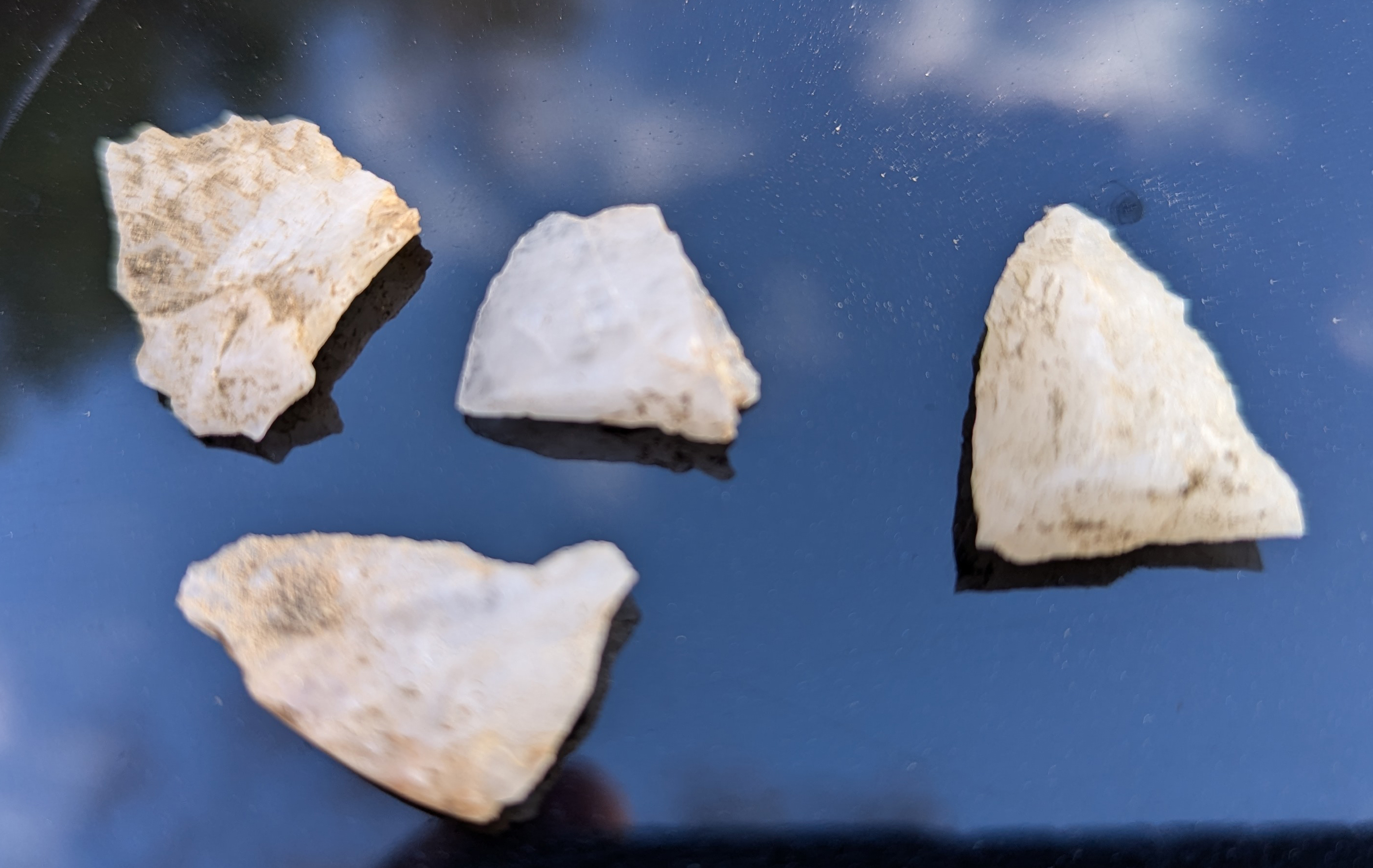 |
| Lithics from Field 1 |
 |
| Dressed for a cold day |
Monday November 18 Linda, Doug, Mary, Elsie, and later Jordan volunteered with Esther to dig additional STPs at the Daffodil Site in the morning. They didn't find that much but it did help define the boundaries of the site. Then in the afternoon they walked the fields. It was another sunny fall day.
 |
| Flagging STP location |
 |
| Documenting STP |
Thanks to Elsie for the info and to Linda for the photos.
On Saturday November 16, another sunny fall day, CCASM members Steve, Doug, Linda, Elsie, Denise, and Ned along with an additional volunteer John worked with Esther on the site. Steve, John, and Doug used their metal detectors. Doug ran a leaf blower. The others flagged and retrieved artifacts from locations identified by the metal detectors and maintained the provenience of the artifacts. They also retrieved artifacts from an ice house pit below the south end of the ridge. Based on the artifacts this does not appear to be the Mount Arundel site. There were some rosehead nails, but most of the artifacts were more later. The oldest artifact was a button possibly dating from 1780-1810 that was found by Steve on the far north end of the ridge.
 |
| A little of every activity |
 |
| Checking out what Metal Detector detected |
 |
| Clearing path for Metal Detector |
 |
| Back of Button |
 |
| Recording location |
Monday November 11 was a sunny fall day. Denise, Doug and Linda joined Esther to clean undergrowth and briars from two strips of land at the Mount Arundel site in preparation for metal detecting this Saturday.
Thanks to Linda for the info.
Monday October 14 we continued to work in the same area as last week. Esther ran lines to several new points. In the morning Denise and Mary dug (mostly Denise dug and Mary screened) several STP's. A lot of rusted metal from a collapsed building, a few pieces of glass, and one ceramic was uncovered. After lunch Esther joined in the fun and helped to dig additional STP's in a wooded area. We finished the day by driving around the fields to check on the status of the soybean crop. Not ready to harvest as of now. The weather was delightful and the soil was easily dug, so a good day in the field.
Thanks to Mary for the info.
Monday October 7 was another beautiful day to be in the field. Denise, Mary, Elsie, and Carol volunteered with Esther to dig four more STPs at Maxwell Hall Site 4. This involved Esther and Denise cutting paths to the STP locations. Each STP had at least one historic artifact. There were lots of pieces of rusty barb wire as well as an early whiteware ceramics sherd, an oyster shell, and nails. We even found some English ivy. Esther reminded us this was where all the daffodils were last spring - another landscape feature that would indicate a residence in the area. A 1930s aerial shows a building in this area. Esther thought we should call it the the "Daffodill Site".
 |
| Starting to clear a path into the brush |
,Mary,Elsie-sm.jpg) |
| Screening |
 |
| More Screening |
Finally a nice day to be in the field even if it did get cut short by rain. Monday September 23 Denise, Elsie, Carol along with a new volunteer Jordan joined Esther in the field at Maxwell Hall Site 4. We dug five STPs and found nineteenth century artifacts in one.
 |
| Documenting |
 |
| Screening and finding no material culture artifacts |
Thanks to Linda and Mary for the info.
Wednesday July 3 was a nice enough day (not too hot) for Esther and CCASM members Denise, Linda, Doug, and Ned to be in the field at the Equestrian Park. The farmer had disced the wheat stubble and completed planting soybeans with a drill in the fields on the Red and Blue trails. Linda, Doug, and Denise walked parts of two of the Blue Trail fields that had been planted after the rain. Nothing was found in the first field, but we found some shell pieces, a couple of flakes, a possible piece of pipe, and two pieces of ceramics in the second one,
Thanks to Ned, Denise, and Linda for the info.
After a number of months we returned to the Equestrian Park on Wednesday May 29. Mary, Gary, and Ned joined Esther at an area on the Red Trail. We dug four STPs in the morning. Then We explored a continuous shell midden along the shores line with Esther wading in the water and Mary walking the upper bank. Gary and Ned set flags at 100 ft intervals to indicate an area to be explode in the future.
 |
| Always paths to clear |
 |
| Stopping for a photo |
Thanks to Mary and Ned for the info and thanks to Mary for the photos.
Monday November 6 we returned to the Equestrian Park. The farmer had just harvested soybeans in part of a field that supposedly had an early colonial building. CCASM members Ned, Peggy, Linda, Elsie, and Carol along with two repeat volunteers Doria and Melaney joined Esther to surface collect for part of the day. We only found two small bricks, but only a small part of the field had been harvested. The field was continuing to be harvested while we were there. After lunch we walked the bluff and on the shore. Esther found at least two new shell middens, and Linda recorded the locations.
 |
| Surface Collecting |
 |
| Recording shell midden location |
But the most interesting thing found were two U.S. Coast & Geodetic Survey Reference Marks that had fallen down onto the shore of the Patuxent.. They were labeled Fodder No. 1 and Fodder No. 2 and were dated 1943. Two reference marks are needed to determine a boat's location on the River.
 |
| Geodetic Survey Reference Markers. |
Thanks to Ned for the additional photo and for the photos of the markers.

Monday October 23 we were able to finish surveying this site (18CH101). CCASM members Mary, Peggy, Denise, Elsie, Ned , and Jim continued digging STPs today. There were three teams - Elsie and Denise; Peggy and Jim; and Ned and Mary (although Mary helped Esther part of the time). We did some additional STPs in the road where it bends along the Patuxent and out on the field's edge.
Thanks to Ned for the info and photo.

Monday October 16 was another beautiful but cooler day to be in the field. CCASM members Mary, Linda, Peggy, Denise, Carol, and Ned joined Esther at the site to dig nine additional STPs. After laying out the grid we divided into two teams with Ned assisting where needed, especially when the digging through the root filled soil became difficult. The STPs did start to define the edges of the shell midden with some STPs having essentially no shells and at least one having a buried layer of densely packed shells. A small amount of worked lithics were recovered.
On Monday September 19, a beautiful day to be in the field, CCASM members Elsie, Mary, Linda, Pat, Carol, and Ned joined Esther to dig shovel test pits (STPs) at the Chalk Point Site in an area above where a shell midden had been found on the shore. We dug eight STPs and found lots of shells in at least three of them as well as a small amount of worked lithics.
 |
| Laying out grid |
 |
| STP Team A |
 |
| STP Team B |
 |
| STP Team C |
 |
| Documenting |
 |
| Shells from STP |
Volunteering for "Maxwell Hall: Discovering and Raising New Voices"
0 comments:
Post a Comment